Chandler Upper Neches Paddling Trail
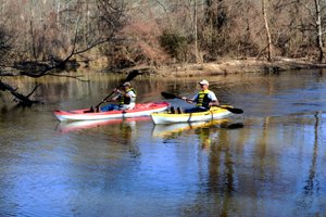
Enjoy a great loop paddling trail just minutes from Tyler and Athens - no shuttle needed! With up to 8 miles of paddling possible, this trail is a great way to explore the Upper Neches.
Trail Access
Chandler River Park
- Type:
- Access Point
- GPS Coordinates:
- 32.3155, -95.4529
1500 Hwy 315 E
Chandler, TX 75758
NOTE: This is an out and back paddle trail with put-in and take-out at the same location.
From Athens: Travel east from Hwy 175 on SH31 for 23.2 miles to Neches River Bridge (River Park, north side).
From Tyler: Travel west on SH31 from Loop 323 for 6.9 miles to Neches River Bridge (River Park, north side).
From I-20: Head south on Toll 49 for 9.9 miles to Hwy 31 and then west on SH 31 for 2.1 miles to Neches River bridge (River Park, north side).
Alternate Access Westberry RV park boat ramp on Lake Palestine
- Type:
- Access Point
- GPS Coordinates:
- 32.2737, -95.4544
17027 CR 1110
Flint, TX
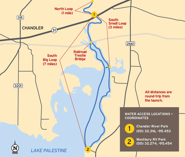
Navigating the Trail
Trail Length: 1-8 mile loop (depending on water levels and with opportunities to extend or shorten as needed based on your turnaround point)
Float Times: This loop trail can be completed in 1-4 hours, depending on water levels, flow rates, and turnaround point for your loop (see map; dependent on water levels, flow rate, and wind).
Trail Description
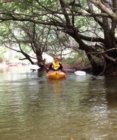
A variety of water types including quiet pools and several small forks off the river are present. Along with the Hwy 31 Bridge, there is also a railroad trestle on the south section of the paddle trail to navigate under. There may also be snags to avoid, especially when water levels are high or low. The Neches River is a natural river that is unrestrained by flood control dams or other manmade structures. As such, the Neches River is readily influenced by rainfall runoff that may create temporary high flows and undesirable water quality conditions. Heavy rains and high water can create dangerous conditions so caution is advised.
Private Property
Respect private property by not trespassing or littering and keeping noise levels down. This river is classified as navigable, which permits public use of the streambed and, if necessary, the banks to portage any hazard. Any other use of private river banks without permission of the landowner can be considered trespassing. Under Texas Penal Code (§30.05), criminal trespass occurs when one enters property after receiving notice not to enter. Notice includes verbal notice, a fence, sign(s), purple paint on posts or trees, or the visible presence of crops grown for human consumption.
Trail Map
Things to Do and See
Fishing
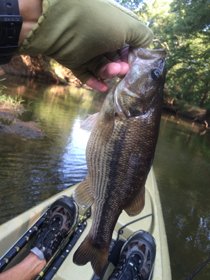
This section of the Neches River supports numerous varieties of fish. The white bass (sand bass) come up into the river from Lake Palestine to spawn in the spring and the fishing is fantastic. Channel catfish, blue catfish, flathead catfish (Opelousas), largemouth bass, Kentucky bass and crappie bite well year-around. Fishing lures such as jigs, plastic baits and spinner baits work well for all types of bass and crappie. Catfish bite well on live bait, night crawlers, chicken livers and punch bait
Wildlife and Ecology
Various waterfowl inhabit this area and during the cooler season, it becomes home to many migratory species. The Tyler Audubon Society has counted over 100 species of birds that frequent the area. Bald eagles can often be seen soaring in the skies and deer are prolific in the area and can
Rentals and Shuttles
Lake Palestine Gateway RV Park
Located adjacent to River Park with direct river access. Kayak and canoe rentals with onsite launch, available to guests and non-guests.
Lake Palestine Gateway RV Park Facebook page
Partnership
This trail was made possible through a partnership between Texas Parks and Wildlife Department and the official trail sponsor, the City of Chandler, as well as the following organizations: East Texas Woods & Waters Foundation, Upper Neches Municipal River Authority, Texas Department of Transportation, and Henderson County.