Bastrop - Wilbarger Paddling Trail
Visit the Bastrop - Wilbarger Paddling Trail in Bastrop, Texas!
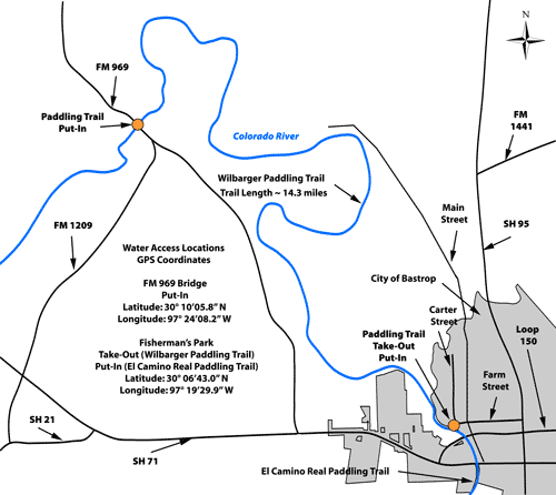
Trail Access
Utley (FM 969) Bridge
- Type:
- Put In
- GPS Coordinates:
- 30.1683, -97.4023
Located at the FM 969 Bridge northwest of Bastrop. Take FM 969 north of Highway 71 just past the intersection with FM 1209.
Fisherman's Park
- Type:
- Take Out
- GPS Coordinates:
- 30.1119, -97.3250
Located at Fisherman’s Park at the corner of Farm Street and Willow Street in downtown Bastrop.
From Highway 71/21 traveling eastbound into Bastrop exit at Texas Hwy 71/21 at “Hassler Blvd, Chandler Street, Loop 150 Exit” and head east (turn left) onto Loop 150 East (Look for “Historic Downtown” sign) and cross the Colorado River Bridge.
From Highway 71 traveling westbound into Bastrop, turn right onto Loop 150 and follow it into downtown.
From westbound Highway 71 or Highways 21 or 95, head west on Loop 150 West (Chestnut Street) into downtown.
Turn north at stop light onto Main Street, and then take a left onto Farm Street. Bear left down to Fisherman’s Park at the fork in the road and the park and boat landing are straight ahead.
Navigating the Trail
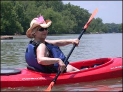
Trail Length: ~6 miles
Float Time: ~1.5 - 4 hours (depending on water levels and flow rates)
Trail Description
Ultimately, there will be at least three Bastrop Paddling Trails located on the lower Colorado River. The upper- and mid-reaches of the river are impounded by six reservoirs, whereas the lower 300 miles of the river is un-impounded and free-flowing below Longhorn Dam. It flows through the cities of Bastrop, La Grange, Columbus, Wharton, and Bay City before entering Matagorda Bay. Though “free-flowing” below Longhorn Dam, flow through this portion of the river is affected by the Highland Lakes, and specifically regulated by Buchanan and Mansfield Dams. As such, the river is readily influenced by rainfall runoff that may create temporary high flows and less desirable water quality conditions. Flow and water quality information is available to paddlers on the web at www.lcra.org/water/river_info.html and http://waterdata.usgs.gov/tx/nwis/uv?08159200. For more information on the trails go to www.environmental-stewardship.org/BPT.aspx
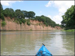
The El Camino Real Paddling Trail is wide and slow-moving with a few minor rapids but no man-made obstructions, although snags and debris should be avoided. The flood plain is flat with a few limestone outcroppings and several exposed cut-banks. As the river moves downstream, the banks of the river gradually steepen and become very scenic with high sandstone bluffs and cliffs. Frequent sand bars and islands provide suitable areas for resting.
Private Property
Respect private property by not trespassing or littering and keeping noise levels down. This river is classified as navigable, which permits public use of the streambed and, if necessary, the banks to portage any hazard. Any other use of private river banks without permission of the landowner can be considered trespassing. Under Texas Penal Code (§30.05), criminal trespass occurs when one enters property after receiving notice not to enter. Notice includes verbal notice, a fence, sign(s), purple paint on posts or trees, or the visible presence of crops grown for human consumption.
Trail Map
Things to Do and See
Fishing
Sport fishing is very good in this section of the river. Popular game fish are Guadalupe bass, blue, channel, and flathead (opelousas) catfish, and freshwater drum (gaspergou). Largemouth bass and sunfish are common in the backwater pools. Light-line and small lures such as jigs, plastic worms, and spinner baits are recommended for spin casting. Heavier tackle is needed for bottom fishing and larger game fish attracted to live bait. Kayak fishing is gaining in popularity. Local fishing guides are available through outfitters.
Wildlife and Ecology
The riparian corridor of the Wilbarger Paddling Trail supports a great diversity of plant and animal life along the river and beyond its banks. Trees to look for include pecan, cottonwood, American sycamore, black willow, bald cypress, hickory, ash, American and cedar elm, roughleaf dogwood, flame-leaf sumac, and red-mulberry. A variety of grasses and vines can be found growing among the trees, while maidenhair fern can be seen clinging to the river banks.
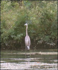
Birders can hope to see Crested Caracaras, Ospreys, Red-tailed and Red-shouldered Hawks, kingfishers, vultures, woodpeckers, Great Blue Herons, Wood Ducks, and Killdeer. In the summer, swallows and Purple Martins are abundant.
The Wilbarger Paddling Trail also provides unique habitat for the blue sucker, a fish species that is depleted throughout its natural range and is listed as threatened in the state of Texas. The blue sucker is one of the most common fishes in the river between Webberville and Smithville.
Rentals and Shuttles
Bastrop River Company
601 Chestnut St, Bastrop
(Conveniently located on the river just 1 block from downtown Bastrop)
512-988-1154
http://www.bastropriverco.com
Cook's Canoes
1004 Water Street
Webberville, TX 78653
512-726-7767, 512-461-7139
www.cookscanoes.com
Rising Phoenix Adventures
306 Industrial Blvd.
(Off Loop 150 Across from Bastrop State Park)
512-677-2305
http://www.risingphoenixadventures.com
Paddle With Style
Martindale, Texas
Phone: (512)749-2350; Operate by reservation only. Able to accommodate large groups.
www.paddlewithstyle.com
Partnership
This trail was made possible through a partnership between Texas Parks and Wildlife Department, City of Bastrop, Bastrop Economic Development Corporation, Bastrop Visitor Center, Rising Phoenix Adventures, Environmental Stewardship, Pines & Prairies Land Trust and LCRA.